
Design and deliver better civil infrastructure with BIM
Autodesk Civil 3D® civil engineering design software supports BIM (Building Information Modeling) with integrated features to improve drafting, design, and construction documentation.
Industry-proven tools for your specific project
Civil 3D features support a variety of civil infrastructure projects including rail, roads and highways, land development, airports, drainage, storm and sanitary, and civil structures.
Advance your workflows with GIS integration and automation
Work with ArcGIS data directly in your Civil 3D design model. Expedite completion of repetitive tasks with design automation.
Features
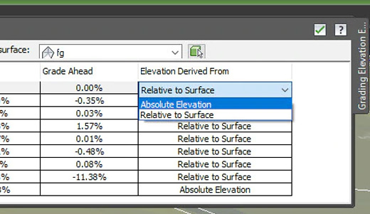
Relative elevation feature lines
Obtain feature lines from a surface or relative to a surface, so feature lines update with changes to the surface.

Dynamic offset profiles
Create dynamic offset profiles using a default cross slope. Modify them by editing the profile properties.

Connected alignments
Create a new dynamically linked alignment and profile that transitions between 2 intersecting alignments and their profiles.

Pipe sizing and analysis
Resize pipes and reset inverts, and compute the energy and hydraulic grade lines according to HEC-22 2009 standards.

Plan and profile sheet generation
Create plan/plan and profile/profile sheets by including multiple plan or profile views on a single sheet.

Label property set data
Add custom data to Civil 3D object labels by using property sets.

Traverse editor
Create points, lines, and curves representing traverse legs and sideshots using COGO input and editing tools.

Corridor overlap resolution (bowties)
Resolve corridor bowties in daylighting conditions.
ENHANCED | InfraWorks interoperability
Use preliminary design models within Civil 3D.
ENHANCED | Pressure pipe networks
Swap pressure network pipes, fittings, and appurtenances with parts of another size or type.
More Features
Civil Design
Corridor design
Tools for corridor modeling.
Extract corridor feature line workflow
Easily extract multiple feature lines.
Advanced roundabout design
Bring new roundabout designs into Civil 3D.
Rail track layout
Streamline the layout of rail tracks.
Point clouds
Use and display point cloud data.
Surface creation from point cloud data
Create TIN surfaces from point cloud data.
Surface modeling
Use tools to create dynamic surfaces.
Grading
Terrain models for grading.
Parcel design
Automated parcel design tools.
Gravity pipe networks
Tools for sanitary and storm drainage systems.
Geotechnical modeling
Tools to help you better plan, visualize, and model geotechnical data.
Drafting & Documentation
Property set definition
Create and use data for any drawing object.
Property data to corridor solids
Automate data and information changes.
Construction documentation
Generate annotated production plans.
Visualization & Analysis
Geospatial analysis
Advanced mapping and analysis functionality.
Storm and Sanitary Analysis software
Dynamic models enable stormwater management.
Analyze gravity networks
Measure pipes and inverts to HEC-22 2009 standards.
Model analysis
Dynamic QTO and earthwork calculations.
Visual analysis
Better understand civil designs with visualization.
Collaboration
Corridor data shortcut (DREF)
Create and share data shortcuts for corridors.
Cache DREF surface
Cache terrain surfaces to share Civil 3D drawings more broadly.
Streamlined reference creation
Add DREFs via simple drag-and-drop operations.
Civil 3D with Navisworks
Gain better predictability.
Civil 3D with Revit
Enhance structural and civil design collaboration.
3ds Max interoperability
Create professional-quality visualizations.
IFC import and export
Import and export AutoCAD solids to IFC files.
System Requirements
System requirements for Civil 3D 2020 |
|
| Operating System | Microsoft® Windows® 7 SP1 with Update KB4019990 (64-bit only) Microsoft Windows 8.1 with Update KB2919355 (64-bit only) Microsoft® Windows® 10 (64-bit only) (version 1803 or higher) |
| Browser | Google Chrome (for AutoCAD web app) |
| Processor | Minimum: 2.5–2.9 GHz or faster processor Recommended: 3+ GHz or faster processor |
| Display Resolution | Conventional Displays: 1920 x 1080 with True Color High Resolution & 4K Displays: Resolutions up to 3840 x 2160 supported on Windows 10, 64 bit systems (with capable display card) |
| Display Card | Minimum: 1 GB GPU with 29 GB/s Bandwidth and DirectX 11 compliant Recommended: 4 GB GPU with 106 GB/s Bandwidth and DirectX 11 compliant |
| Disk Space | 16 GB |
| Pointing Device | MS-Mouse compliant |
| File Format Changes | AutoCAD .DWG format – R2018 Civil 3D Object format – R2018.2 ¹ ¹ New vertical curve profile entities (fixed vertical curve by high or low point) are not supported in Civil 3D 2018. |
| .NET Framework | .NET Framework Version 4.7 |
Additional Requirements for large datasets, point clouds, and 3D modeling |
|
| Memory | 16 GB RAM or more |
| Disk Space | 6 GB free hard disk available, not including installation requirements |
| Display Card | 1920 x 1080 or greater True Color video display adapter; 128 MB VRAM or greater; Pixel Shader 3.0 or greater; Direct3D®-capable workstation class graphics card. |